Where the radar is blind
INEA Macaé (S-band) beam blockage — from the data and from the terrain
CONVECT / Project Sharktopus
· radar property, shared by all three cases
· defense-in-depth for the radar DA pipeline
Does the radar have directions where it rains and the radar
never sees it? Yes — a wide western arc behind the Serra do Mar,
plus a few man-made dead sectors. We pinned them down two independent
ways: by reading years of the radar's own echo statistics, and by
simulating the beam over the terrain from the radar's exact position.
The INEA Macaé radar sits at −22.405832°, −41.860462°,
antenna height 81 m, 1.0° beam, 0.5° lowest sweep, out to
250 km. East of the radar is open ocean (no terrain, no blocking); the
blind directions are inland, to the west and north-west.
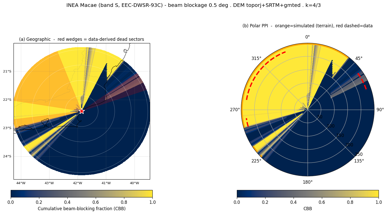
Cumulative beam-blockage fraction (CBB) at the 0.5° sweep.
Left — geographic, with the data-derived dead sectors as red wedges.
Right — polar PPI: orange = simulated terrain blockage,
red dashed = persistently dead sectors from the data. Range rings every
60 km to 240 km. Radar at the centre star.
Three azimuth bands are persistently dead in the radar data:
54–71° (NE, over the sea), 254–262° (W) and
279–339° (W→NW→N). Together they blank roughly
19% of the d03 footprint and ~45% of the d04 footprint
(audit finding AU5-6). The terrain simulation independently reproduces the
western bands — and, honestly, does not reproduce the NE band, which is
the tell that NE is man-made clutter, not topography.
Two ways to find a blind spot
Approach
What it measures
Strength
Blind to
A · From the data
Azimuths that carry no echo across many volumes, regardless of
weather (audit AU2-6 / AU5-6).
Sees the real blockage — terrain, towers, buildings,
near-field obstructions — all at once.
Cannot say why a sector is dead.
B · From the terrain
Partial/cumulative beam blockage (PBB/CBB) from the beam
geometry over a 30 m DEM, 4/3-earth refraction.
Says why, and predicts blockage the data have not yet
sampled. Reproducible from first principles.
A 30 m DEM cannot see man-made obstructions (towers, the
near-field, the radome mast).
Approach B is a small in-house calculation (no wradlib/gdal):
beam-centre height by the 4/3-earth law, half-power beam width
abeam(r)=r·tan(Φ/2) with Φ=1.0°, the Bech (2003) partial-blockage
fraction against the terrain height, accumulated along range
(CBB = max-so-far of PBB — blockage only gets worse with distance).
Terrain comes from the WPS_GEOG DEMs (toporj 30 m → SRTM → GMTED),
with a global land/sea mask forcing the ocean to 0 m so regional-DEM edge
artefacts cannot invent offshore mountains.
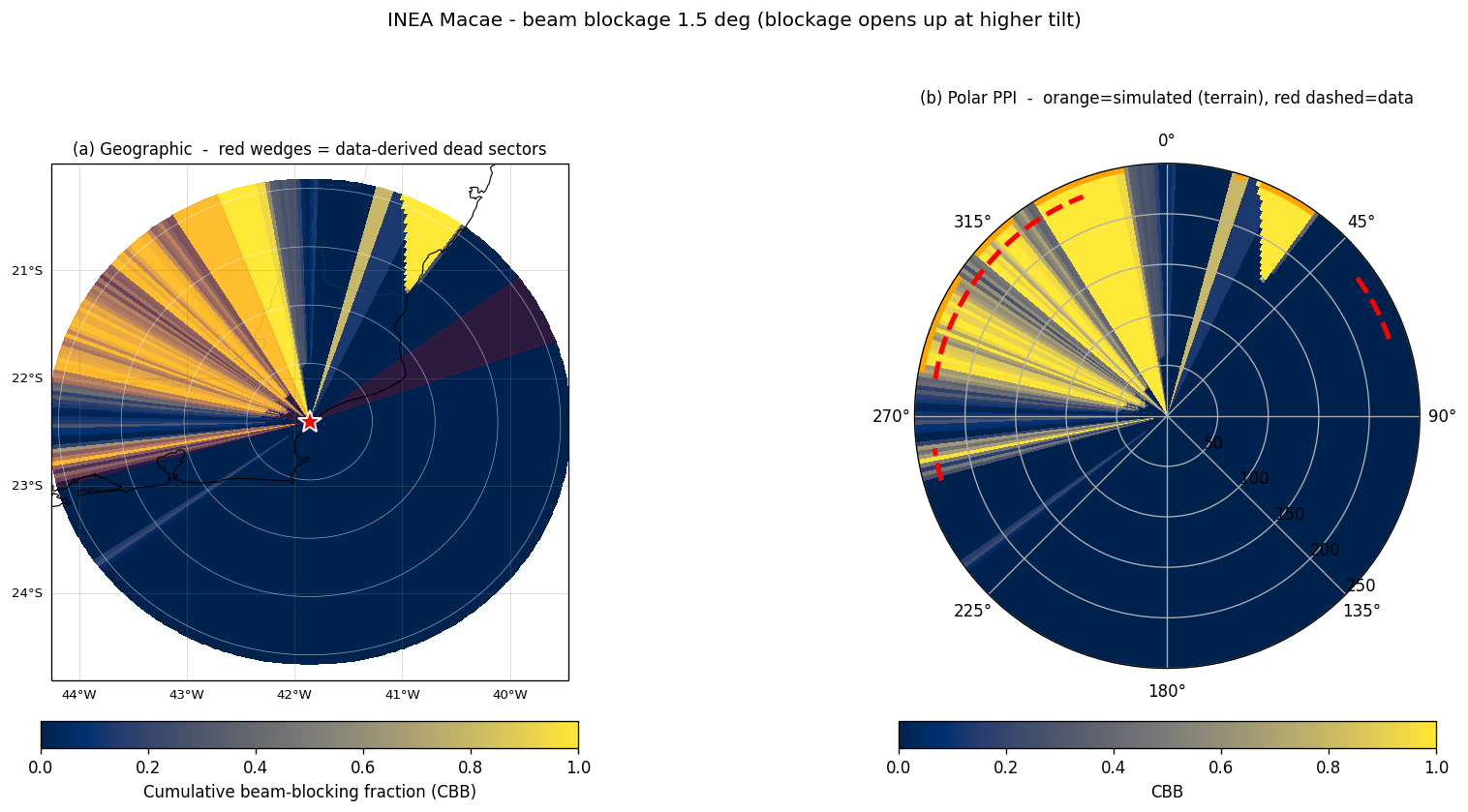
Same map at the 1.5° sweep. Tilting the beam up lifts it
over much of the terrain — the western blockage shrinks but does not vanish.
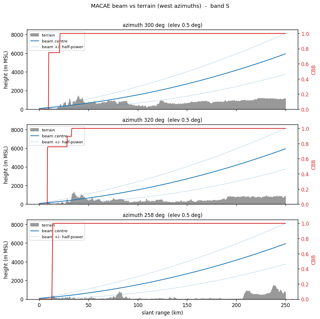
The lowest (0.5°) sweep is the worst case and the one the mask targets.Beam centre and ±half-power envelope vs terrain along three
western azimuths (300°, 320°, 258°). The Serra do Mar drives CBB to 1.0
within the first tens of km — the beam is fully buried beyond it.
Where the two agree — and where they don't
Dead sector (data)
Direction
Terrain explains it?
Reading
54–71°
NE, over the sea
no — 0% terrain
Open ocean under the beam. Man-made clutter / near-field
obstruction, not topography.
254–262°
W
yes — 100% terrain
Serra do Mar foothills bury the 0.5° beam within ~10–25 km.
279–339°
W → NW → N
yes — 100% terrain
The mountainous Macaé hinterland; the simulated terrain arc
(254°→N→38°) covers this entirely.
The disagreement is the most informative part. The terrain
simulation independently confirms the two western dead sectors — the
beam is provably buried in the Serra do Mar — but produces no blockage
for the NE 54–71° band, because there is only sea in that direction. A 30 m DEM
cannot see towers, buildings or the near-field, so a sector that is dead in the
data yet open in the terrain simulation is almost certainly an
artificial obstruction or ground clutter, not the landscape. This is
exactly the kind of cross-check that a single method cannot give you. The
western terrain blockage corroborates the independent prior study of
Silva, Amorim & Paz (2022), who ran partial beam blockage
over a NASADEM for the same radar and found ~100% blockage beyond ~20 km toward
the W/NW at the 0.5° elevation (III Encontro Nacional de Desastres, ISSN
2764-9040, IME).
What this means for the data assimilation
A blocked gate sees no echo even when it is pouring rain there. If that
"no echo" were assimilated as reflectivity = 0, WRFDA could read it as
"no rain here" and dry out the analysis. So the blocked azimuths must be left
missing, never written as a zero. The mask file
macae_blockage_mask.json makes that exclusion explicit and
independent of any quality-control threshold, and it is wired into the ODIM →
ob.radar converter via --blockage-mask: every ray in a
blocked azimuth is dropped whole, so its gates stay absent rather than becoming
false zeros.
Honesty note — this is defense-in-depth, not a
bug fix. The C2 audit specifically tested the hypothesis that beam
blockage had poisoned the radar analysis, and refuted
it (findings AU2-7 / AU4-3): the converter's own quality control (SQI ≥ 0.3)
already leaves the blocked sectors absent — a benign gap, not a field of
false zeros — and the negative innovation in that case came from real 10–30 dBZ
echoes, not from the terrain. The mask therefore does two honest things: it makes
the exclusion explicit and threshold-independent, and it protects the
verification truth field (about one-fifth of d03 is blind to this radar,
so a radar-only "truth" must not be read as ground truth there). On one C2 volume
(2024-01-21 01:00 Z), 366 of 1470 radar reports (25%) fell in blocked
azimuths and were withheld; the masked ob.radar is a strict subset of
the unmasked one — only the report-count header changed, no observation was
altered or written as a zero.
Downloads
The map, the WRFDA mask, the drop-in sector list, and the full continuous
CBB grid. The sector list is compatible with the existing
--blocked-az argument; the NetCDF carries CBB/PBB/terrain/beam-height
on the polar grid with full provenance attributes.