Objective 4-domain nest placement for WRF radar data assimilation A case study over Macaé / INEA radar, 21–22 January 2024 · draft for WRF User Meeting 2026

CONVECT / Project Sharktopus · last updated 2026-06-11 (audit revision — see erratum) · source on GitHub

Where should the WRF nest go for a radar-DA case study? Today the answer is "by hand". The 1 km nest has to contain both the radar and the day's active convection — and the decision has to be made before the DA is run. Get it wrong by 100 km and the experiment is dead.

This site documents an objective, container-based pipeline that (1) places the d02/d03/d04 nests from a composite of standardised convective-index anomalies, (2) decides whether the day is convectively supported at all using a 3-month WRF climatology (DJF 2022–23, n=1087), and (3) runs the full WPS → real → WRFDA 3D-Var → ndown chain end-to-end.
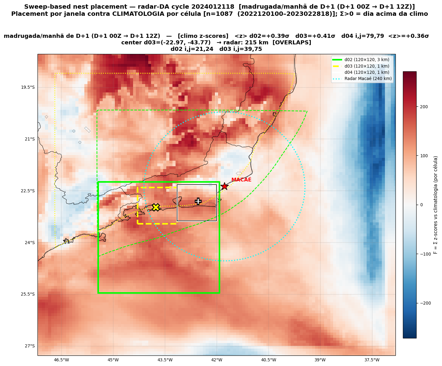
Nest decision overview for Macaé 2024-01-21
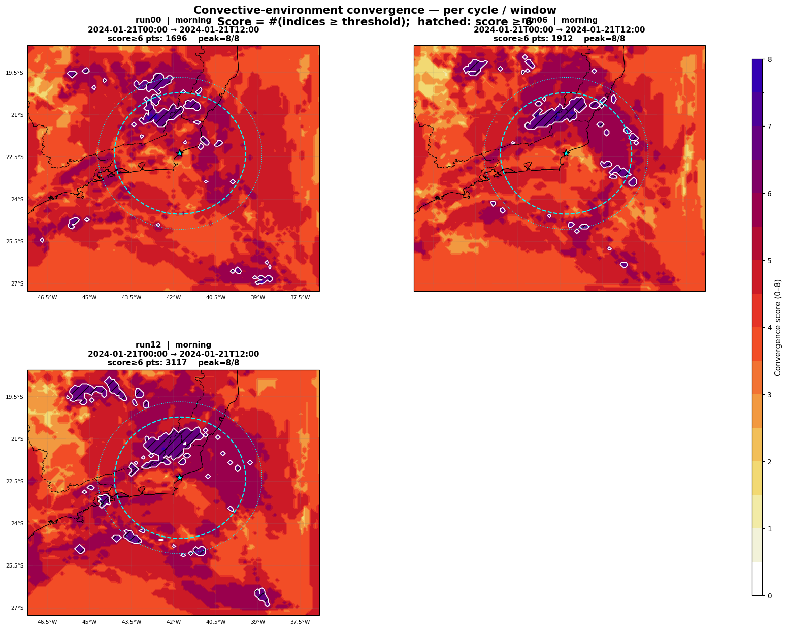
Nest decision overview — d01 9 km composite anomaly with placed d02 / d03 / d04 boxes. Macaé radar marked in black.
case
Macaé 21–22 Jan 2024

2 windows: morning (00–03 Z), afternoon (06–09 Z)

afternoon climo <z>
+1.00σ

favourable — ~top 16% under a Gaussian assumption (see erratum E6)

morning climo <z>
+0.40σ

mildly favourable — above climatology, below 1σ

DA cycles
8

4 morning + 4 afternoon (independent windows; the afternoon restarts from the GFS 20/12Z pre-forecast), hourly 3D-Var, rv + rf

Novelty vs prior art. Ingredients-based forecasting (Doswell et al. 1996), composite parameters (Thompson et al. 2004, 2012), standardised climatological anomalies (Hart & Grumm 2001), EFI for convection (Tsonevsky et al. 2018), and WoFS-style relocatable domains (Skinner et al.) are all individually standard. The combination — composite z-scores of many indices across many forecasts and times, swept for a fixed-size box, with a climatology-referenced algorithmic go/no-go — is what, to our knowledge, is not yet published.

Navigate the story

Climo-anomaly composite with nest box
01 · placement

Where should the nest go?

Interactive picker for both windows, with dual self-score and climo-score boxes side by side on the same composite field.

Open the picker
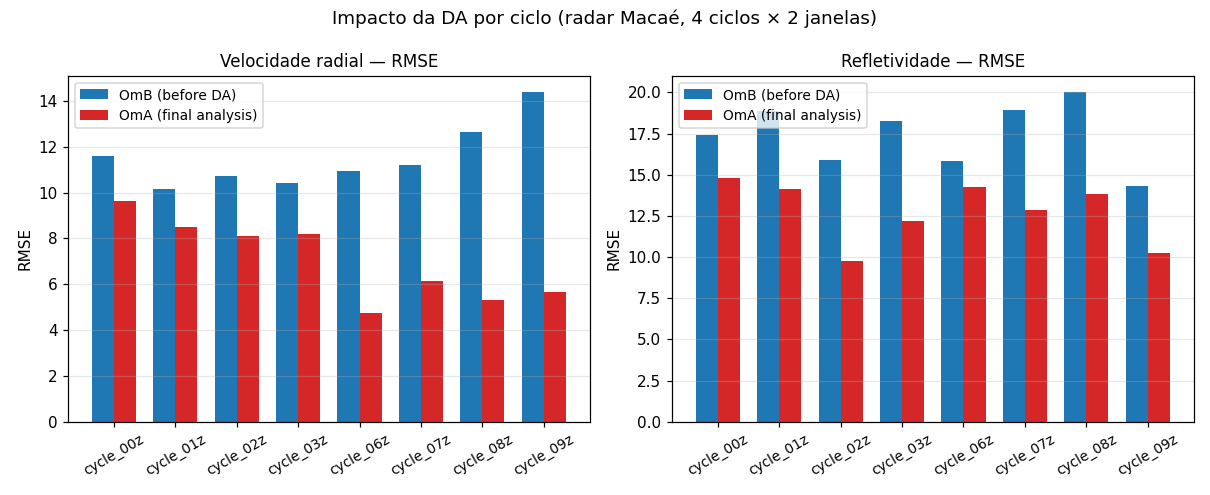
RMSE OmB → OmA summary across 8 cycles
02 · innovation

Did the DA move the state?

Eight 3D-Var cycles, cost function, OmB → OmA fit, and 3-D analysis increments of U, V, T, Qvapor around the radar.

Open the innovation report
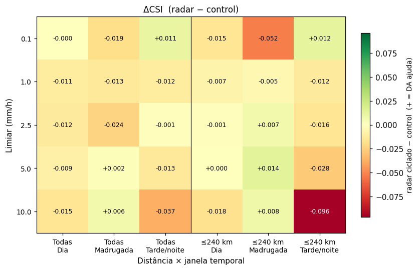
Delta-CSI (radar minus control) by precipitation threshold, window and distance
03 · verification

Did the free forecast benefit?

Control vs radar-cycled WRF, verified against the INEA Macaé composite reflectivity and ~200 rain gauges at d01, d02, d03 — plus the d04 out-of-coverage check, where the DA measurably degrades the forecast (see erratum E5).

Open the verification report
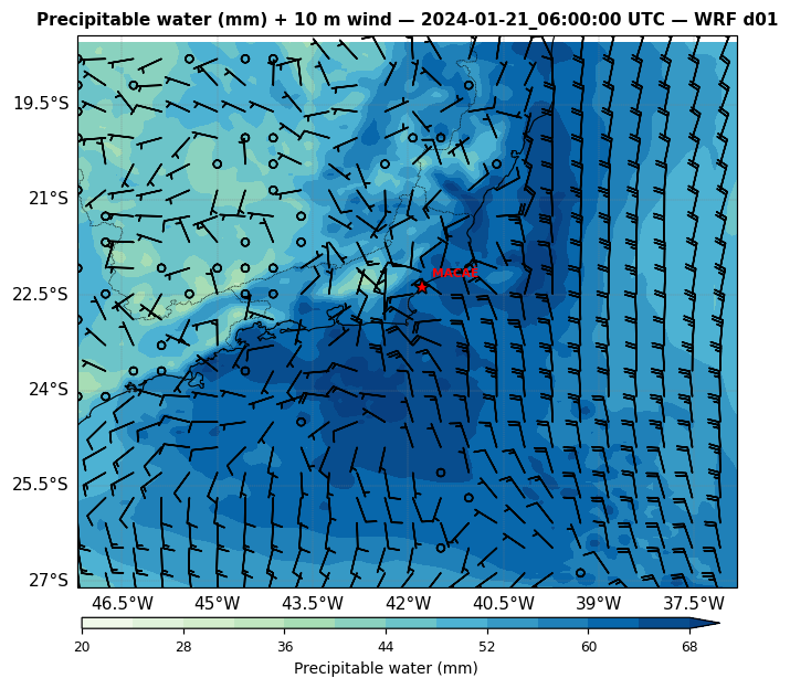
Precipitable water — moisture band over SE Brazil
synoptic situation

Synoptic context of the event

Pre-rendered d01 frames for 8 synoptic fields — MSLP, T2, q 850, Z500, jet 250, precipitable water, CAPE/shear, and composite reflectivity. Compare the radar-DA run with the fair control.

Open the synoptic explorer

Pipeline at a glance

The whole chain is containerised — fetcher, runner, assimilator, plotter. One invocation of the suggest_nest tool reads a coarse d01 run plus the DJF 2022–23 climatology NetCDF, writes a picker HTML, and emits a namelist.wps and namelist.input ready to drop into WPS → real.exe → WRFDA. The DA stage assimilates radial velocity and reflectivity from the INEA Macaé volume scans on an hourly 3D-Var cycle; the final forecast is driven by ndown down to 1 km.

Key numbers for the Macaé case

window climo <z> d03 / d04 i_par (d01..d04) j_par (d01..d04) DA cycles
morning 00–03 Z +0.40σ radar / Angra sibling 1, 21, 58, 17 1, 24, 77, 70 4 (00,01,02,03 Z)
afternoon 06–09 Z +1.00σ radar / NW in-coverage sibling 1, 41, 69, 29 1, 47, 72, 66 4 (06,07,08,09 Z)

Common grid: d01 9 km 120×110, d02 3 km 121×121, d03 1 km 121×121, d04 1 km 121×121 (sibling of d03). Radar Macaé INEA at (−22.406°, −41.860°).

Erratum — audit revision of 2026-06-11

This page was re-issued after a full multi-agent audit of every generation step (radar conversion, DA cycling, MET verification, aggregation and reporting). The pre-audit state is preserved in git (tag published-v1-leandromachadocruz; pipeline tag pre-audit-2026-06). The central conclusion — radar 3D-Var materially improves the precipitation forecast inside radar coverage at convection-permitting resolution — survives all corrections. What changed:

Methodology, evidence and before/after for all 104 audit findings: AUDITORIA_RADAR_DA_2026-06.md in the pipeline repository.

Minimal bibliography